facebook
twitter
google plus
Linkedin
youtube
Orders over $100 ship FREE
800-338-6228
All Categories
alaska
Alaska (232)
alaska
Atlantic (255)
alaska
Great Lakes (134)
alaska
Gulf (160)
alaska
Pacific (213)
Search
$
0.00
0
Home
Shop for nautical charts
Customer Login
Show Cart
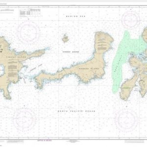
Baker, Noyes, and LuluIslands and adjacent waters (chart 17406)
Home
Shop for nautical charts
Products
Baker, Noyes, and LuluIslands and adjacent waters (chart 17406)
Home
/
Shop for nautical charts
/
Alaska
/ Baker, Noyes, and LuluIslands and adjacent waters (chart 17406)
Baker, Noyes, and LuluIslands and adjacent waters (chart 17406)
$
21.00
Nautical chart scale
: 1: 40,000
$
Quantity
Add to cart
Chart ID:
17406
Category:
Alaska
Description
Additional information
Description
View this chart on the NOAA Chart viewer
Additional information
Weight
32 oz
Dimensions
42 × 4 × 4 in
Related products
Adak Island to Tanaga Island (Metric) (chart 16467)
$
21.00
Select options
Andrenof. Islands Tanga Bay and approaches (chart 16462)
$
21.00
Select options
Barren Islands (chart 16606)
$
21.00
Select options
facebook
twitter
google plus
Linkedin
youtube