facebook
twitter
google plus
Linkedin
youtube
Orders over $100 ship FREE
800-338-6228
All Categories
alaska
Alaska (42)
alaska
Atlantic (21)
alaska
Great Lakes (24)
alaska
Gulf (33)
alaska
Pacific (130)
Search
$
42.00
2
Home
Shop for nautical charts
Customer Login
Show Cart
Lynn Canal-Icy Str. to Point Sherman;Funter Bay;Chatham Strait (chart 17316)
Home
Shop for nautical charts
Products
Lynn Canal-Icy Str. to Point Sherman;Funter Bay;Chatham Strait (chart 17316)
Home
/
Shop for nautical charts
/
Alaska
/ Lynn Canal-Icy Str. to Point Sherman;Funter Bay;Chatham Strait (chart 17316)
View cart
“Cook Inlet-southern part (chart 16640)” has been added to your cart.
Lynn Canal-Icy Str. to Point Sherman;Funter Bay;Chatham Strait (chart 17316)
$
21.00
Nautical chart scale
: 1:80,000
$
Paper Options
*
36 lb. JCP E-50 Chart Paper [+$5.00]
24 lb. JCP E-20 High Wet Strength Paper
Quantity
Add to cart
Chart ID:
17316
Category:
Alaska
Description
Additional information
Description
View this chart on the NOAA Chart viewer
Additional information
Weight
32 oz
Dimensions
42 × 4 × 4 in
Related products
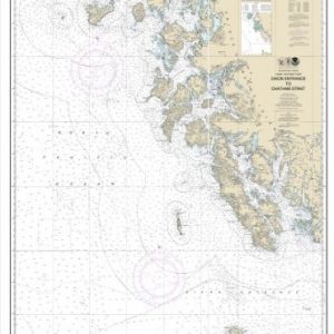
Dixon Entrance to Charham Strait (chart 17400)
$
21.00
Select options
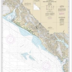
Cross Sound to Yakutat Bay (chart 16760)
$
21.00
Select options
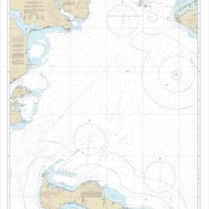
Bering Sea, St. Lawrence Island to Bering Strait (chart 16220)
$
21.00
Select options
facebook
twitter
google plus
Linkedin
youtube