• facebook
  • twitter
  • google plus
  • Linkedin
  • youtube
Orders over $100 ship FREE 800-338-6228
NOAA Charts
$0.00 0
  • Home
  • Shop for nautical charts
  • Customer Login
  • Show Cart

Category: Atlantic

  • Home
  • Shop for nautical charts
  • Products
  • Atlantic
  • Page 2
Home / Shop for nautical charts / Atlantic / Page 2

Atlantic

Showing 13–24 of 256 results

  • Baltimore Harbor (chart 12281)

    $21.00
    Select options
  • Bar Harbor Mount Desert Island (chart 13323)

    $21.00
    Select options
  • Barnstable Harbor (chart 13251)

    $21.00
    Select options
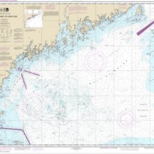
  • Bay of Fundy to Cape Cod (chart 13260)

    $21.00
    Select options
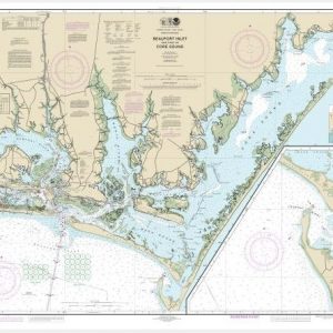
  • Beaufort Inlet and Part of Core Sound;Lookout Bight (chart 11545)

    $21.00
    Select options
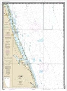
  • Bethel Shoal to Jupiter Inlet (chart 11474)

    $21.00
    Select options
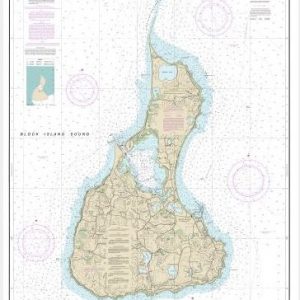
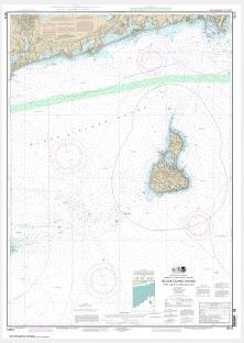
  • Block Island (chart 13217)

    $21.00
    Select options
  • Block Island Sound and Approaches (chart 13205)

    $21.00
    Select options
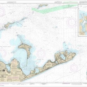
  • Block Island Sound and Gardiners Bay; Montauk Harbor (chart 13209)

    $21.00
    Select options
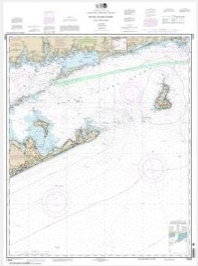
  • Block Island Sound Point Judith to Montauk Point (chart 13215)

    $21.00
    Select options
  • Blue Hill Bay;Blue Hill Harbor (chart 13316)

    $21.00
    Select options
  • Boothbay Harbor to Bath, Including Kennebec River (chart 13296)

    $21.00
    Select options
  • ←
  • 1
  • 2
  • 3
  • 4
  • 5
  • …
  • 20
  • 21
  • 22
  • →

Chartside Map Locators

Looking for a specific nautical chart?

Download these helpful chartside indexes to find the chart you're looking for quickly.

Regions

  • Alaska
  • Atlantic
  • Pacific
  • Great Lakes
  • Gulf

(all chartside files are PDF format and are very large, be patient during download on slow connections)

Contact Us

Feel free to contact us if you have any questions.

  • 8119 Central Ave.
    Capitol Heights, MD 20743
  • HBudd@whmap.com
  • 301-336-1143
  • 800-338-6228
  • 301-336-5520
  • http://whmap.com/

Map Production

We have the staff, software and equipment to handle all aspects of cartography and map production. Our large library of software titles can accommodate the processing and editing of any customer-provided final files.

We are also able to create new maps by utilizing files output from a GIS environment, integrating such data with accompanying text and graphics (photographs, logos, street indexes, tables, etc.) into a clean, publication-quality layout.

Long Term

Williams & Heintz Map Corporation has been printing maps for entrepreneurs, government agencies, and map publishers for over 93 years. We combine the highest quality pre-press, printing, and folding with industry leading knowledge and customer service.

Sustainable

Williams & Heintz understands the importance of building and maintaining a cleaner environment and aims to contribute in as many ways possible throughout our map production and printing cycle.

We are continuously improving elements in our map making and printing process to produce the same high quality custom maps with far less negative impact on the environment.

Versatile

At Williams & Heintz, we can assist you with any aspect of map production and manufacturing, from the simplest 1-color map to the most complicated 12-color map, from 3″ x 5″ to 47 ¼ ” x 63″. Send us your digital files, or films and camera copy.

We welcome your difficult reproduction problems and complex technical maps as well as simpler jobs. All will get the same care and attention to detail that maps require, at a competitive price.

  • facebook
  • twitter
  • google plus
  • Linkedin
  • youtube
© 2022 Williams & Heintz Map Corporation. All Rights Reserved.

Web Design by Solnet